When I was about ten-years-old, I had a secret hideout on the chalk escarpment above my primary school in Folkestone. My gang and I would sneak out the back gate of the school, across the fields and up the steep slope to the World War Two pillbox that was the base of our operations.
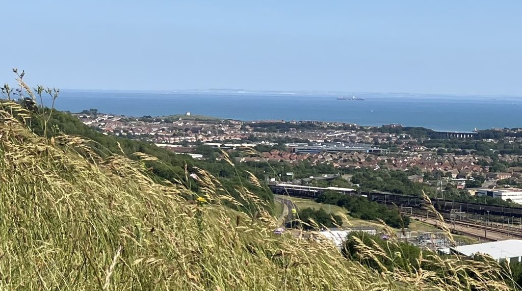
I did not really appreciate it at the time, we were too busy playing war games, but from up here you can get a distinct sense of just how connected this corner of Britain is with mainland Europe. On a sunny day, you can see the white cliffs of Cap Blanc-Nez gleaming in the distance, cliffs that are composed of exactly the same Upper Cretaceous rocks that you are standing on. If you follow the contours of the chalk ridge from my hideout to the east, and out across the water, it does not take much imagination to see how intimately the two sides of what is now the English Channel were once linked.

Looking southeast from the chalk ridge above Folkestone across the English Channel to Cap Blanc-Nez
In geological terms, the English Channel is a very recent construction. The erosion process took hundreds of thousands of years, but it was only about 8,000 years ago, after the last Ice Age, that the land bridge between mainland Europe and Britain was finally severed. Prior to that, at different stages, the chalk escarpment was the foundation of an ancient trackway or series of trackways – the oldest roads in Britain – that facilitated the mass migration of the earliest humans to Britain.
The chalk stretched all the way from Northern France to Salisbury Plain in southwest England and made the movement of early humans into this unexplored territory relatively straightforward.
The chalk was sturdy underfoot, afforded clear views of the road ahead, and avoided the impenetrable and dangerous woodland and swamps below. The numerous chalk springs provided an endless supply of fresh water, and the soil was awash with flints, which could be fashioned into tools and weapons.
The ridgeway remained an important highway even after Britain became an island, as is indicated by the series of stone megaliths dotted along the route all the way from the coast to Stonehenge. One of the most important collections of megaliths is either side of the Medway Valley, a fertile settlement area and a key junction along the trackway, just south of today’s Rochester. It marks the point where the chalk ridge, which heads northwest inland from the coast, makes an abrupt turn and heads in a more or less direct line southwest to Stonehenge.
More evidence of the route’s popularity was uncovered in 2005 when the remains of young man with an amber necklace were found outside Amesbury. Tests suggested the young man had come all the way from the Mediterranean to visit Stonehenge, perhaps as part of a Neolithic grand tour or an early pilgrimage to the druidic temple.
More recently, this ancient trackway has become associated with another kind of pilgrim, those Medieval devotees travelling to the shrine of Thomas Becket in Canterbury Cathedral.
However, there is little evidence that this route was really used by the pilgrims. Indeed, Canterbury is not even on the chalk escarpment but about ten miles northeast of it down the Stour Valley. The conflation of ancient road and pilgrim trial was largely the result of the efforts of a few 19th century romantics eager to rebrand the Pagan road as a Christian highway.
The so-called Pilgrims’ Way follows the chalk ridge most of the way however both the eastern and western termini have been moved from Stonehenge to Winchester and the coastal port of Dover, to Canterbury.
Hilaire Belloc, the prolific Franco-English writer, devout Catholic and determined hiker, in his 1904 book, The Old Road, contends that the eastern terminus of the ancient trackway would have naturally shifted to Canterbury because the city was equidistant from all Kentish ports and just upriver from the tidal reaches of the Stour River, making it a more reliable and flexible destination than one single port on the coast. Similar logic was used to fix the western terminus at Winchester on the edge of Salisbury Plain rather than Stonehenge.
It was this new route, from Winchester to Canterbury, the Pilgrimists argued, that Henry II travelled on after returning to England from France to do penance for the murder of Thomas Becket in Canterbury Cathedral. And as such, they deduced, it would become the favoured route of all subsequent pilgrims paying homage to the murdered saint.
However, it is pure speculation that Henry II took this route; it is more likely he went to London first. And generally, it makes much more sense for later pilgrims to use the roadways leading out of London that were first built by the Romans rather than a barely recognisable rural pathway. In Geoffrey Chaucer’s Canterbury Tales, the pilgrims set out from the Tabard Inn in Southwark and would have almost certainly travelled along the old Roman Road of Watling Street, where there was plenty of lodging available, rather than a desolate, narrow, winding track to the south.
The Canterbury Tales is of course a work of fiction but as Chaucer correctly notes, most pilgrims were urban professionals who could afford the trip, not farm labourers tied to the land. As such they would probably not be up for roughing it on their travels: I can’t imagine the Wife of Bath, for example, pitching a tent on a windswept hillside. The only real advantage for well-to-do pilgrims in avoiding the main highway was that they were less likely to encounter bandits lying in wait.
It is entirely possible that some medieval pilgrims did follow route proposed by Belloc: There is documentary evidence that one Richard of Southwick, a merchant and burgess of Southampton, did so in the late 13th century. It is doubtful however that this was as ever the primary or definitive path, as proclaimed by the Pilgrimists, rather it is likely there were a multitude of paths chosen by different pilgrims with different needs.
Undeterred by the lack of any real evidence, Hilaire Belloc was keen to stress both the primacy and antiquity of his chosen route. Just outside Canterbury, his party rested at Bigbury Camp, an Iron Age hill fort, a site that for the romantic author symbolized the intricate link between the medieval and ancient pathways:
History and the prehistoric met at this point… On this hill the two categories mingled, and a bridge was thrown between them. For it was here that the Roman first conquered. This was that defence which the Tenth Legion stormed: the entrenchment which was the refuge for Canterbury.
Again, there is little evidence that Bigbury was the site of the epic battle that brought “civilization” to Britain, although it certainly was a well-established fortress around that time.
However, Belloc’s ideas quickly gained traction and it was not long before the ancient trackway along the chalk escarpment and through the valley to Canterbury became entrenched in the popular imagination as the Pilgrims’ Way.
Thanks to Belloc and the other Pilgrimists, the Pilgrims’ Way is now a permanent fixture of the southern English countryside, marked on Ordinance Survey maps, clearly signposted along its 150-mile length, and religiously followed by thousands of hikers and pilgrims alike each year.
But the original Old Road remains in place, and is now known as the North Downs Way. When the Pilgrims’ Way turns towards Canterbury, the North Downs Way continues along the old ridgeway, above the Devil’s Kneading Trough, across the Elham Valley and back up to hills above Folkestone where I used to play as a child.

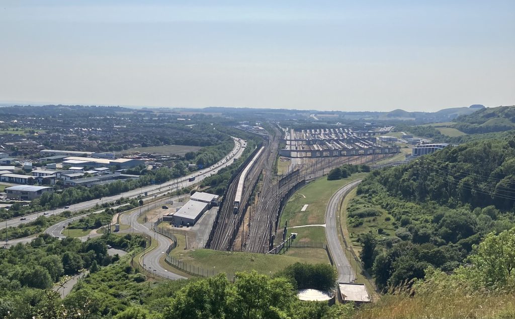
Above the entrance to the Channel Tunnel looking west along the chalk line
Today, the route from my school to my old hideout is blocked by the vast Channel Tunnel terminus. Here modern travellers can drive their car onto the train and be transported underground through the chalk and emerge the other side in France. The tunnel’s route mirrors almost exactly that ancient roadway along the chalk escarpment that once linked Britain and Europe, and it re-establishes that vital connection severed some 8,000 years ago.