Sixty years ago, Tsing Yi was a small rugged island off the west coast of Kowloon, inhabited by a few thousand residents who eked out a living by fishing or growing rice and vegetables. Many lived in stilt houses or small boats in a semi-circular lagoon that stretched inland for several hundred metres from the northeast coastline. There were no bridges linking the island to the mainland, and the only access was by boat. Because of the strong currents offshore, a trip to the nearest port in Tsuen Wan could often take more than an hour by rowing boat.
The first permanent link to the mainland, Tsing Yi Bridge, was only completed in 1974, during Hong Kong’s economic boom period. The bridge was financed by a consortium of local companies who needed road access for the power station, warehouses, cement plants and oil depots that had mushroomed along the coast. However, the bridge also allowed for the growth of residential and commercial developments such as Tsing Yi Town on the northeast edge of the lagoon, which was linked to the bridge by a narrow causeway. See map from 1975 below.
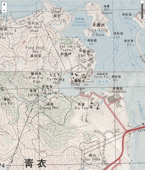 In the 1970s, Tsing Yi Town was dominated by a large agricultural market building; there was also a primary school, a rural committee office, and even a mansion that housed the Tsing Yi Overseas Chinese Fraternal Society. The main town was surrounded by farms and a fetid shanty town that stretched out across the lagoon. At the eastern end of the narrow high street was the ferry pier, which even after the completion of the frequently gridlocked bridge, remained a vital link with the mainland.
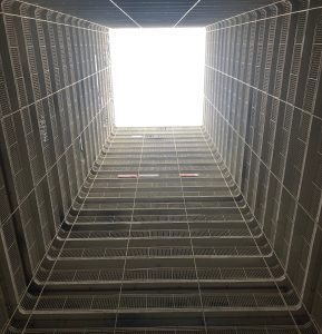
The new bridge facilitated the construction of the island’s first public housing estate, the Cheung Ching Estate, in the adjacent hills. The estate consists of a dozen identical pale yellow and blue tower blocks dotted across the hillside, and linked by a baffling complex of passageways. Each building has a cold, dark interior courtyard, and when you gaze up at the tiny patch of sky high above the lines of dull metallic balconies, it feels more like a prison than a home. See photo below.
 The only slightly less depressing Cheung Hong Estate was developed in the 1980s, on the hillside further inland. At the same time, the government finally got around to reclaiming the lagoon, plans for which had been on the drawing board since the 1920s at least. The first new building complex on the reclaimed lagoon site was the Tsing Yi Estate, which consists of four residential tower blocks and a commercial centre. Soon after that, a housing, shopping and leisure complex called Tsing Yi Garden was built on the former site of Tsing Yi Town.
The southern and western fringes of the old lagoon are marked by today’s Fung Shue Wo Road. Outside this perimeter road, there a half a dozen new villages built in the 1980s and 90s to provide housing for families displaced from the lagoon and coastal hamlets.
These tightly-packed three-storey village housing blocks are just about the low-rise residential developments on the island now – everywhere else is at least 25-stories high. Life proceeds at a slower pace here and there is still something of a village atmosphere. Family-run shops and cafes, hair-saloons and traditional Chinese medicine clinics occupy several of the ground floor premises and the residential buildings are interspersed with small courtyards and temples. It seems a world away from cacophonous shopping malls just down the road.
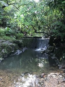
One of these new settlements, Lam Tim village, occupies the former site of the Chung Mei hamlets that used to line the banks of the stream flowing into the lagoon. Today, that stream is mostly buried in a drainage channel underneath Lam Tim village but you can still see a trickle, sometimes more than a trickle after a typhoon, flowing through the steep-sided valley in the adjacent Tsing Yi West Road Park.
 There is more evidence of old village life up in the surrounding hills, which are dotted with the graves of villagers. Some are quite plain, others are grandiose structures with magnificent views down the valley and overlooking the harbour all the way to Hong Kong island. New graves are always under construction, and, in some sections of hillside, the dead are as now as closely packed as the living.
In the mid-1990s, Tsing Yi finally got a second bridge to relieve the traffic jams on the narrow original structure. The construction of the four-lane north bridge to Tsuen Wan also considerably enlarged the northeast corner of the island by swallowing up a small islet called Nga Ying Chau and its natural harbour that was home to a substantial fishing community. Many harbour residents had previously been relocated during the Tsuen Wan reclamation, and were now moved again, this time to the purpose-built settlement known as Tsing Yi Fisherman’s Village, on to the hillside to the north of Tsing Yi Park.
Nga Ying Chau was partially levelled during the reclamation process and an upscale housing estate, Villa Esplanada, was built around it on the site of an old oil depot. However, you can still see the remnants of the islet in the wooded rocky outcrop southwest of Villa Esplanada. See photo of Villa Esplanda from the top of what is left of Nga Ying Chau.
The land reclaimed from the sea to the south of Nga Ying Chau was developed into the Maritime Square shopping centre and the Tsing Yi MTR (airport express) station, a sports complex with a swimming pool and running track, and a waterfront promenade that stretches all the way down to the new Tsing Yi Pier that today acts primarily as a drop off point for tugboat crews in the container port rather than a ferry dock for residents.
There are now no less than eight road and rail bridges linking the island with both the mainland and Lantau Island, making Tsing Yi, located almost equidistant from Chek Lap Kok Airport, downtown Hong Kong, and Shenzhen Bay, one of the most important transportation hubs and logistics centres in Hong Kong.
The population of Tsing Yi is already approaching 200,000, and the growth rate shows no sign of slowing down. There are at least four new housing developments currently underway; near the vocational school in the south, high up in the northern hills, and an expansion project at the original Cheung Ching estate, where new buildings are being shoehorned into the last remaining gaps in the hillside.
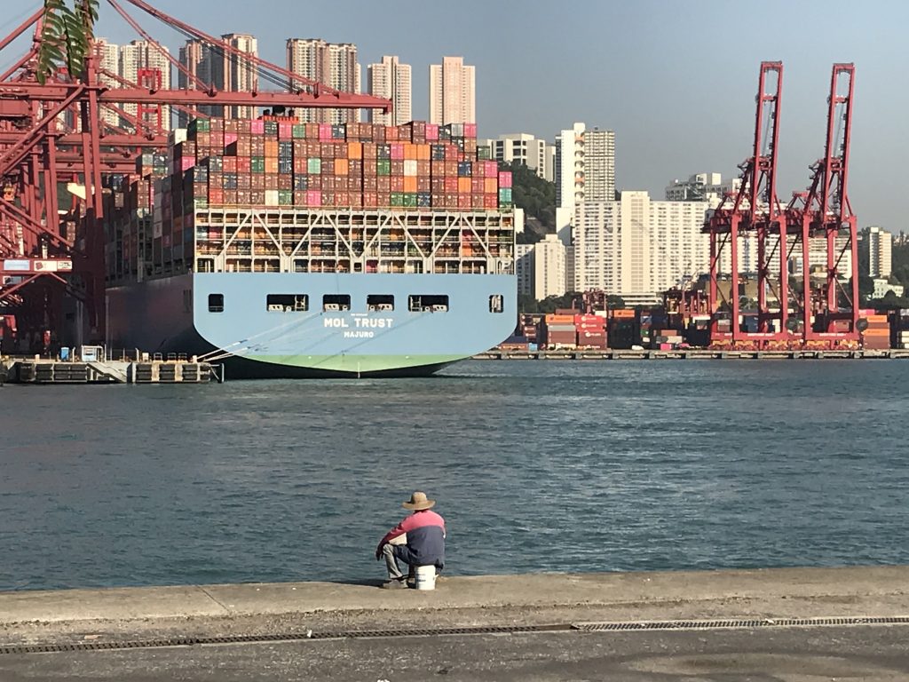
Despite all the housing and infrastructure development, the island still retains its maritime feel. The boat repair yards on the north coast are still there, there is an active dragon boat society, and every day the waterfront is lined with hundreds of anglers who do occasionally land a big one.
 The temple of the Goddess of the Sea is now hidden away on a hillside, down an alley between the new fire and ambulance stations, but it still receives occasional visitors.
Further inland, you can still escape up into the hills along a network of well paved pathways that lead through the trees all the way up to the highest the three peaks, known as the three incense sticks, whose profile has long symbolised Tsing Yi.
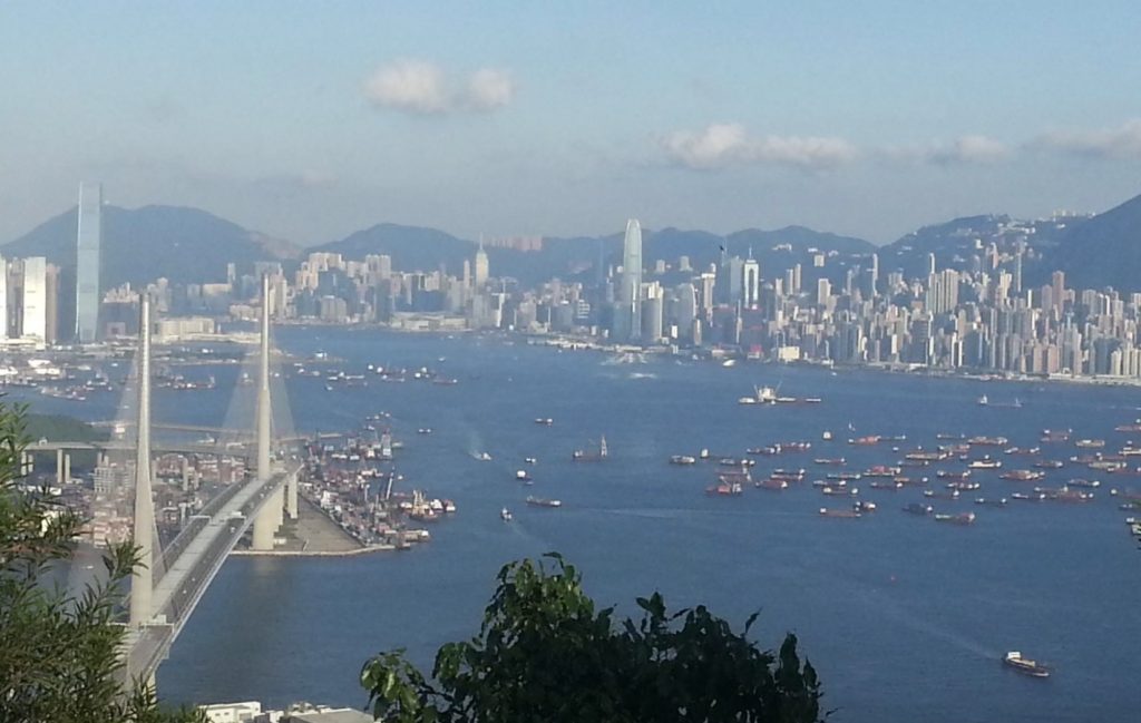
The view from the top of Tsing Yi’s highest peak, looking over Stonecutters Bridge towards Hong Kong island.
It is difficult to imagine what Tsing Yi will look like in another 60 years. Who knows, if Carrie Lam and her friends have their way, it might not even be an island anymore, just part of an amorphous mass of reclaimed land stretching across the former harbour all the way to Shenzhen.
To get a sense of just how much Tsing Yi – and the rest of Hong Kong – has grown over the last 170 years, please visit the fantastic resource that is the Hong Kong Historic Maps online archive.